Brownseys Travelography - The Sequel

This is my second blog - a 'travelography' of some of the places to which I've taken my camera. It's the sequel, the 'overspill' blog to my first one, which I managed to fill up! If you like the way this one is shaping up then check out the original (see 'more photos')

Monday 29 August 2011

Cardigan Bay

The need to get away from work coupled with a desire to re-visit the Welsh coast resulted in a much a weekend break in mid-Wales, or more precisely, to coastal location which was also close to the Ynys-hir nature reserve and to a Red Kite feeding centre, aka BBC Springwatch and Countryfile respectively! We chose Aberaeron as our base, a pretty Georgian coastal town, and apparently one of Wales's first planned towns. We were not disappointed.

Sixteen miles south of our destination we stopped off at the well known town of Aberystwyth, which had all the pre-requisites for a UK seaside town. A Victorian pier, bustling promenade, sandy beach and impressive row of pretty pastel hotels all formed part of the gently sweeping curve of the bay, which was itself flanked by Castle ruins at one end and a grassy headland at the other. And somewhere in the middle was 'The Olive Branch', offering not just peace, but also food! Once fed and watered, we spent an hour or so exploring what Aberystwyth had to offer, and as usual we left clutching postcards, local maps and walks and a personal photographic representation of Aberystwyth.

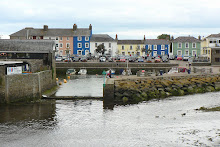
By the time we arrived in Aberaeron, we were keen check into our B&B, and then to check out whether this little town and harbour lived up to the stunning photographs on the website. The only marketing misconstruction was that the sky above the harbour is not always blue! But as if to make up for this, the colour of just about every building in Aberaeron is as pretty as a paintbox of pastel watercolours. We wandered around the harbour familiarising ourselves with our new home for the weekend, before embarking our first walk, one which traced the meandering River Aeron inland, along ancient tracks, sometimes edged with woodland, or hedgerow, but always with a feeling of being at one with nature. Some 2 hours later, the harbour welcomed us back with a silver sunset.

The next morning we were ready for a hearty breakfast, so stocked up on carbohydrates for the day ahead. A full 'Welsh' breakfast, cereal, dried fruits, yoghurt, toast and marmalade, and every variation of tea known to man (or at least to Linda the landlady) was on offer. We set off down the coast with a list of pre-researched places to visit, and the first stop was at Cymtydu. Difficult to pronounce, but easy to love. Cymtydu Cove was virtually uninhabited, no buildings, no cars, no people, just nature. Unfortunately nature was doing its best to hide the charms of this place by shrouding it in a cloak of mist. But we rose above this, literally, as we climbed away from the beach up and round the headland on the coastal path. Our plan to follow Walk No 8 in our book began with the best of intentions, but the weather had other plans. We cut short our walk and returned to the car, damp but no less enthusiastic about exploring this coastline.

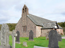
Our second stop was even shorter than the first, in fact we didn't stop until we had passed through Llangranog, a little town nestled between 2 headlands, picturesque and peaceful, but wet, so the intention was to call in on the way back. However a quick stop for a couple of backward view shots was all we were to see of Llangranog. Penbryn beach was calling, and with it our third stop and Walk No 3! We were getting a feel for the coastline by now. Small and smooth sandy coves, deep and craggy inlets, grassy headlands, thinly populated but thickly verdant, and stunning surrounding landscapes. Our walk began from the beach, wound upwards onto the headland, inwards through woodland, and upwards further across meadows until we reached a tiny little whitewashed Church on top of the hill. St Michael's Church has ancient 12th Century origins, purportedly. It even boasts a circular churchyard. We will probably remember it for the friendly curly-coated sheep who found solace and shelter in the remote church-yard and who were not afraid to be patted and photographed by passers by, possibly the first they had seen for some time! The walk back down through the wooded valley was quicker, partly due to descent being quicker than ascent, but the promise of a cafe, coffee and cake might have helped.

Our 4th stop was equally as unpronouncable and pretty as Cwmtydu. Mwnt is a National Trust treasure. Not just because of free membership car parking, but because this gem of a cove is set into a crown of soft green fields and rolling hills ... and one hill in particular which promised us our 4th walk, and the best of views across this picturesque haven of peace. The ascent up Foel y Mwnt began from another tiny whitewashed pilgrimage church, this time with origins in the 6th Century. But we bypassed the sacred for secular as we continued upwards through the brief break in the mist and murk, with the prospect of a view driving us forward. As we climbed the track steepened, and our car became a dot on the green landscape and the handful of people on the pale cream sand were specks. But as we approached the top of the hill the wind whipped up, the mist descended and the outstanding and long distance views were washed out. Once again another quick descent was called for but as we reached the bottom the sun came out once again. Fickle weather aside, it had been a fun climb and worth the damp battering for the views along the way. Taking advantage of continued sunshine we went down onto the beach and enjoyed looking at 'our' hill from a very different perspective.

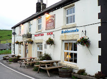
Cardigan was to be our 5th and final stop of the day. We anticipated spending a couple of hours in what I presumed to be the largest town in Cardiganshire, the County town. Cardigan (or Aberteifi if you're Welsh) was indeed once a hugely influential port, located on the River Teifi estuary. The little market town and harbour is pretty enough, but after an hour we came away confident that we had seen and captured as many views and postcards of Cardigan as was necessary. No cardigans were purchased though. Contrary to popular belief (and mine) these garments were named after James Thomas Brudenell, 7th Earl of Cardigan.

With unexpected additional time on our hands we moved on southwards to Poppit Sands, mainly because it sounded like fun. Personally I would drop the 'Poppit' from the name! But we found a photogenic section of beach where barnacle covered rocks held our photographic interest for a while.

We arrived back at Aberaeron early in the evening, with appetites and anticipations high for a fish and chip supper on the harbour wall, watching the small world of Aberaeron go by, and the sun go down. Fish, chips, and sun, were met expectations and went down very well!

Sunday morning arrived far too quickly. So much still left to see and do, and so little time. Should we go to the annual Aberaeron Cob Fayre? Our landlady Linda was certainly keen that we shouldn't miss this local event, and had we been staying a week, we would have done so. The cob is a small horse, of stout build, with strong bones, large joints and a steady disposition - so a body type rather than a specific breed of horse. That aside, the call of Nature Reserves was stronger than that of Cob Horses, so we said our goodbyes to the pastel pallet town of Aberaeron and drove northwards up the coast.

En route to our first nature reserve we came across Borth, which can best be described as a linear town - strung out along the coastline with the sea in front and nothing but marshland behind. The best views of Borth and beyond were seen from a Viewpoint high above the town. In the distance, and sitting at the base of the most southerly hills of Snowdonia National Park, the Dyfi estuary flows out into the sea. The estuary forms the border between the counties of Ceredigion and Gwynedd - essentially between north and mid-Wales. It also marked the most northerly point of our visit.

Driving through the long town of Borth and out the other side, we failed to realise that its beaches held a secret only revealed by the tide. An ancient submerged forest is apparently visible at low tide along the beach, where stumps of oak, pine, birch, willow and hazel can be seen. Radiocarbon dating suggests these trees dies about 1500 BC! Radiocarbon dating suggests these trees died about 1500 BC. A missed opportunity for us, but other than sacking the researcher for this weekend, there was little we could do!

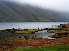
But we didn't miss the opportunity to explore the Ynyslas National Nature Reserve, just beyond Borth. The reserve was cunningly disguised as the beach, but actually comprised a mixture of peatbog, estuary and dunes which offer a rich home to feeding wading birds, wild flowers and rare orchids. Also a home to dead jellyfish and invading pirates (in the Information Centre!), and an opportunity for us to walk, explore and photograph all that his most northerly corner of Cardigan Bay had to offer.

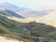
Just 7 miles further down the road we arrived at Machynlleth, home to the Ynsy-hir Nature Reserve, and to the new BBC Springwatch site. Set amongst forest and rolling hills, edged by the now narrow and meandering River Deifi and overlooking a stunning lake, it is hardly surprising that the BBC were keen to make this the new home of Springwatch in 2011. Before embarking on one of the 4 trails around the Reserve, we were treated to an impromptu guided tour of the 'Springwatch' home, and an insight into what it was like having an 80-strong BBC production team on the Reserve for some weeks. We viewed the converted Tractor Shed cum Studio with its ecologically planted grass roof, the wooden and environmentally built patio cum broadcasting balcony, the televised compost heap and home to snakes and the swallows nest in the barn. And next Spring we will view these once again, but from a new enlightened perspective.

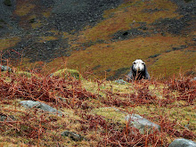
We decided to follow the Wetland Trail, the longest of the 4 routes around the Reserve, but the one with the best views of the estuary. The walk in itself was rewarding for the landscape, which was just as well, because other than sheep, any wildlife was hidden, even from the Hide! But once back at the Information Centre we watched chaffinches, coal tits, blue tits, greenfinches, and siskine fly back and forth to giant bird feeders as they tucked into their tasty seed. We on the other hand, sat watching them from our bench as we tucked into big buttery biscuits and massive mugs of coffee! But it was time to move on to bird feeding on an altogether larger scale.

Our final stop of the day, and of the whole weekend, was in Bwlch, at the Forestry Commission Visitor and Red kite Feeding Centre. Dinner was due to be served at 3.00 pm so a degree of planning and clock watching was required. But not so for the Red Kites! At 3.00 pm the food was distributed by the lake, over a small area no bigger than 20 feet wide. Within minutes the grey skies gradually began to fill with the familiar calls, distinctive tails, and unmistakable silhouettes of the Red Kite as they gathered in every increasing numbers, encircling, waiting, watching ... then swooping down a few at a time, taking their fill and delighting the crowd. We left the area delighted by what we'd seen, but amazed at how 60 or more Red Kites from miles around had turned up on time, en masse, and on cue for their dinner ... and not a clock in sight! Sadly their flying speed and location was too high to capture the spectacle adequately, but it was a fitting high point at which to leave Wales and head home.


Saturday 16 October 2010

Norfolk

A late summer weekend break was much needed and Norfolk was the natural choice, for an unspoilt coastline, uncrowded towns, unlimited choice of places to explore, and an undemanding and short journey time. We decided to make our base Cromer, and had set our sights on The Paris hotel, overlooking the pier, and looking slightly less grand that it might have done in its heyday. We affectionately referred to it as our 'shabby chic' option. But it was not to be. Booking in advance was difficult, with priority given to coach-parties. The prospect of battling for a seat at breakfast resulted in a booking at our second choice. The Red Lion. This overlooked the sea too, and our 'superior room' was indeed a superior choice!

But as always, the journey is part of the holiday, and we took the opportunity to 'hop and stop' at regular intervals along the North coastline, starting with Winterton-on-Sea - a pretty village with several attractions. The beach was typical of many on this North Norfolk Heritage Coast. Wide sweeping sandy bays, flanked by dunes, walked by dogs and their owners, home to hardy seal colonies and loved by photographers! In spite of the grey skies and nip in the air we took our first walk along the pretty shoreline following the long winding trail of pink and red seaweed which the waves had deposited just for our photos, it seemed, before turning tide and retreating. But beyond the sea-shore the horizon was also offering opportunities.

A far distant wind farm punctuated the horizon, the giant majestic turbines just getting on with their work, unobtrusively, silently and photogenically. Last but not least, and clearly not wishing to be ignored, a small group of seals kept bobbing up out of the water, added interest and amusement to the crowd of onlookers (which equated to around 5 people and a couple of dogs). As if not to be outdone, a hobby (falcon), who was clearly also on holiday, was on the beach doing his own beachcombing - for food!

After a quick re-visit to Horsey Windpump, where the skies were even greyer than our first visit, we hopped up the coast to re-visit Sea Palling, which had made quite an impression on me previously. A turning too soon took us to Horsey Gap, a break in the dunes just south of Sea Palling, but it had a useful sea wall on which to eat our picnic!

Sea Palling, like Winterton-on-Sea, is off the beaten track, quiet and un-commercialised. As with it's neighbour down the coast the turbine-edged horizon is still visible, but it also has the added interest (from a photographic viewpoint) of a line of sea defence barriers and boulders attempting to hold back the sea, and a concrete wall (with curve appeal!), doing its best to protect the dunes from further erosion - a reminder that the ebb and flow of the sea is not always as benign as it appears. Armed with photos and wind-chapped cheeks, we left the beach to find some Walls which were less defensive ... I chose a pecan and maple and enjoyed every last lick!

The last and longest stop-off en route to our base at Cromer was always going to be Happisburgh. Much publicised by the media, much battered by the sea and much photographed and loved by us! This is coastal erosion at its worst, crumbling cliffs at their most volatile and family homes at their most vulnerable, facing their inevitable fate.

Looking for all the world like a D-day scene from a World War II movie, the sea defences on the beach at Happisburgh do their best to prevent the forces of nature from reclaiming the land. Some would say a futile attempt, others that not enough is being done. Whatever stance is taken, the endlessly long line of posts, poles and ramps that line this shore continue to be smashed, twisted, ravaged and rusted by the relentless battering of the waves, making this one of the saddest yet most inspiring sights on any UK coastline. Man's attempt to protect the land from the sea is certainly a force to be reckoned with, but is surely no match for the forces of nature. But what we saw on our final stop of the day reminded us that nature can also be silently stunning.

As we approached Cromer the heavens opened! And whilst our Superior Room at The Red Lion gave us superior shelter, the views of the sun setting in a moody sky drew us back out - for a plateful of fresh Cromer Crab in the Garden Street Grill, followed by a the best vantage point for a sunset - the pier.

As crowds of Cromer holidaymakers bustled along the shiny, slippery wooden walkway for the 'Seaside Special' finale of the Season, keen to get out of the wind and rain, two hardier weekenders instead lagged behind, keen to stay outside and watch the weather unfold. The reward was a perfect rainbow arch over the sea, from the end of the pier to the end of the Cromer coastline. And as the sun set in the sky and Cromer turned pale pink, we turned in ourselves, tired but already looking forward to the day ahead.

On day 2 we awoke early to a blue, cloudless sky! Keen to make the most of such glorious weather we decided on a quick pre-brekkie walk - eastwards towards the colourful row of beach huts, then back to the pier, looking resplendent and altogether different from the previous evening. And after a hearty breakfast of homemade yoghurt, smoked salmon and scrambled egg, toast and marmalade and copious cups of coffee, we set off westwards along the North Norfolk Heritage coastline.

First stop was Sheringham, colourful flags draped across narrow streets, shops full of trinkets, pavements littered with tourists - so after a few of our own purchases we moved on to find somewhere that wouldn't litter our photographs!

Weybourne was a delightful surprise, and was officially nominated as my favourite beach of the weekend! Nature once again caught my breath. Norfolk's infamous expanse of blue sky was covered in fluffy white clouds in regular patterns; the North Sea had amazingly turned blue and was fringed with frothy white waves crashing onto the unspoilt, unadultered and deserted shingle beach, which in turn was flanked by miles of low, grass-topped, frilly sandstone cliffs which snaked along the coastline, inviting walkers with cameras and dogs to follow it!

Loathe as I was to leave Weybourne, we wanted to see so much more of this coastline, and whilst our next stop was an old favourite we had an ulterior motive for going there ... .

Blakeney Nature Reserve has so much to offer. Wildlife aside, there are colourful boats, curvacious creeks, crazy dog-owners and cream scones! We took advantage of them all, and didn't let the worsening weather deter us from enjoying a short walk along the creek. Neither did the crazy dog-owner let the creek deter him from rescuing his escaped dog from the far bank! Dressed only in his underwear and top, he was resolute in his quest as he waded waist deep in the muddy waters, watched by amused and amazed onlookers. He rescued his dog, but I imagine his pride and ego are still in the creek!

Our ulterior motive for stopping at Blakeney was to check out the departure point for our planned boat trip to Blakeney Point to see the Seals. Once we'd established that the boat left from Morston rather than Blakeney Quay, we set off on our quest to find 'Beans Boats' and moorings ... which turned out to be unmissable, well-sign posted and bright orange! Our penultimate and unplanned stop of the day was at a Duck Museum.

Well, a Tank Museum actually, but I still claim that the graphics on those brown information signs are open to misinterpretation! The Muckleborough Collection is Norfolk's largest working military museum, full of tanks, Yeomanry vehicles, guns and missiles, all waiting to be photographed. Getting up close and personal with a Doodle Bug and Harrier was an unexpectedly moving experience, and well worth the visit alone. But time and weather was drawing in, and we wanted to make one last stop before heading back to Cromer, to Wells.

Wells-next-the-Sea isn't anywhere near the sea. It used to be apparently. But silting has reclaimed the land, turning the area into salt marsh and creating a haven for bird life. We neither had the time nor the inclination for the long trek to the sea on this occasion, so instead took to the narrow, colourful and bustling back streets which are now a haven for tourism. Ominous clouds had followed us back to Cromer, and it soon became clear that there was only one way to spend the evening. The decision was unanimous ... we sat on the pier, eating fish 'n chips, whilst storm watching! The sky was thunderous, the reflected lighting over Cromer awesome, the occasion magical, and the fish 'n chips yummy!

The day of our Beans Boat trip was upon us, and after the storms of the previous evening, we anxiously looked out across the sea, hoping for a flat calm sea but anticipating a choppy churned up one! It was somewhere in between. And after another hearty breakfast (and sadly our last), we made tracks. With time to spare we were able to stop at West Runton, recommended by a friend as the 'type of beach I would like'. True enough, West Runton was deserted and dramatic. A line of craggy cliffs atop the beach, a line of dark defences along it and a band of sand on which to walk, twixt shingle and sea. It was a bracing one, but as luck would have it, a break in the clouds revealed blue sky ... and by the time we reached Morston Quay the blue of the sky was reflected in the creeks, and our boat trip was looking even more inviting.

We'd been told to look for a man in a bright orange top - Mr Baked Bean presumably. Given this information, we thought it was probably safe enough to walk a mile or so up creek without any danger of missing him! So there we were, up the creek without a paddle ... but with cameras to keep us occupied. By the time Mr Bean arrived in his bright orange top, the sky was looking stunning ... row upon row of ever-decreasing fluffy white cotton-wool balls were strung across the bluest of blue backgrounds. We queued, we paid, we boarded, we were off! About 20 of us bobbing up and down in Bean Boat, up the choppy creek, across the harbour and out to the sandspit - a sanctuary to some 5000 Norfolk seals.

We must have seen around 500 seals and a good few pups; the remainder of the colony would have been out at sea, doing what seals do when they're not lolling about on sandspits. Not that we were left without information ... Mr Bean took advantage of his captive audience and lost no time in feeding 'all aboard' with snippets of information about the feeding and breeding habits of Seals. And we left the Bean Boat well informed, well 'captured' and well peckish! Back on terra firma we indulged in freshly made, freshly caught crab sandwiches, ideal sea food after a ideal sea trip. We continued with our wildlife theme at the next and last planned stop of our weekend.

Pensthorpe Nature Reserve and Conservation Centre has been on my 'to do' list since Springwatch, and I was more that a little excited at the prospect of seeing first hand what I'd enjoyed on television. The fact that the blue sky had turned to grey and that rain was in the cool did nothing to dampen my enthusiasm. The Reserve had a lot to offer, and not just in terms of birds (though it has to be said that I've never seen so many species in such a relatively small area!). We decided to take a 'Discovery Tour', a ride in a Jeep trailer across the Reserve, and an ideal opportunity to see the extent of the site and what it offered. The driver/guide knew his stuff, could spot a kestrel at 500 metres and an emperor butterfly at 50 ... and all whilst driving around the winding tracks of the Reserve. He also flagged up various bat boxes, badger setts and birds of prey stands and nest sites which had been the focus of much camera attention on Springwatch. The tour ended with freebie Jordan's cereal bars ... not so random once you learn that the Jordan family now own Pensthorpe, and live on the Reserve!

The weather was gradually deteriorating as we set off on foot to check out the various recommended points of interest. Across walkways which spanned the ponds, lakes and mere; through the Millenium gardens, along the edge of the woodland area, down the bug walk, through the aviary, across the Conservation area and past 'Five Cottages', 'The Barn' from which Kate Humble, Chris Packham and the BBC film crew had presented Springwatch.

Points of interest? For one particular inquisitive bird (a Northern Bald Ibis), it was Alec's camera strap, who clearly wasn't interested in having his photograph taken. For another bird (a brightly coloured and love-sick pheasant) the only focus of interest was a potential female breeding partner, and she most clearly wasn't interest in him, and the pair darted between and around the shrubbery reminiscent of demented but comical cartoon characters!

My own points of interest included several camera-oblivious red squirrels, the plethora of colourful and photogenic ducks and geese who clearly owned Pensthorpe and waddled freely but noisily along and between the walkways, enjoying the attention of passing tourists who got in their way.

There was just time for a quick coffee in the Courtyard Cafe, and a warm up, before the gates shut behind us for the day, and reminded us that our weekend was also coming to a close. But first we had to find somewhere to eat ... easier said than done in rural Norfolk! We eventually found found on a Dutch floating Clipper, The Albatros.

Moored in Wells-Next-The-Sea, The Albatros is one of the oldest sailing ships still afloat. These days she is permanently moored and a tourist attraction, offering Dutch Pancakes and a different but fascinating historical atmosphere in which to eat them. The Albatros was built in Rotterdam in 1899 used as a cargo ship exporting grain from Denmark to Sweden. She even assisted Jewish refugees with their escape from Nazi Germany during WW2. Latterly she served Greenpeace as an environmental study centre for schoolchildren, before funds were cut... and today a couple of genial university students earn their keep by waiting on tables ... and entertaining tired, hungry, but very happy customers at the end of their packed photographic weekend in Norfolk.

Monday 5 April 2010

Scottish Highlands

It had been quite a dilemma deciding exactly where our holiday should be based for our foray into the 'Far North Highlands'. We wanted to explore completely new and unknown territory; to see remote areas, mountains, to cover as much of the East, North and West coastlines as was humanly possible in a week, to stand on the tip of mainland UK, to visit The Orkneys - and to stay in an isolated crofters cottage central to everything on our wish list! But it took my tenacious and pedantic nature some considerable time to accept that something would have to 'give', and after a crash course in Highland geography and the road networks it became obvious we would have to forego 'Mountains' and the 'West Coast' for a future foray. As The Orkneys was top of the list then our base would need to be relatively close to the North and East coasts, ie the districts of Sutherland and Caithness, aka 'The Peatlands' and 'Flow Country.' The perfect cottage was located ... 40 miles South of John O'Groats, 8 miles inland from the East Coast, in the middle of nowhere and 600 miles from home! The holiday had begun ... but the epic journey still lay ahead ... .

We had two options. Plan A involved a flight to Inverness plus a hire car for the week; Plan B involved a very long but scenic drive, and our own comfortable car with big boot. Plan B was eventually voted favourite by the driver, and endorsed by the passenger! When 13th March arrived we were catapulted into the holiday by an early dawn alarm at 4.00 am and we were soon well on our way on the largely traffic-free roads. We crossed the Scottish border after 5 hours and 300 miles, and enjoyed a welcome break at a 'Welcome Break' on the Motorway ... but we were still only half way to our final destination! A further 200 miles and we were ready for lunch. A picnic in the Cairngorms, surrounded by the stunning snow-covered peaks of Aviemore was an unexpected treat ... but the biting cold wind a chilling reminder of what we might have to expect for the week.

After a further brief stop at Cromarty en route (for no reason other than hearing the name on the BBC Shipping Forecast for many years), we arrived in the pretty coastal town of Helmsdale around 4.00 pm, 600 miles on, 11 hours after setting off, and with enough daylight left to check out our local town's attractions and amenities, before driving the final 8 miles of our epic journey up the Kildonan Valley to our cottage. And after a brief phone call to owner of the cottage to let her know we were arriving soon, we also had to stop for some coal for the fire!

The road to Kirkton Cottage was filled with eager anticipation and excitement! It was also one which exceeded our expectations for a peaceful, remote holiday location. As the narrow single-track road left Helmsdale far behind, it continued on its way, twisting and turning along the pretty banks of the River Helmsdale, flanked by huge heather-clad hills and punctuated every mile or two along the way with the occasional crofter's cottage with puffs of smoke swirling up from their chimneys (maybe the 'Clean Air Act of 1952 is not applicable in such remote rural areas). But it was quite clear that this valley belonged not to the cottage owners, but to the herds of sheep and red deer who momentarily stopped grazing to check out who was driving on their road and through their landscape. If we were in any doubt about it this point was reinforced on arrival at the cottage, as, fixed to the gatepost was a sign saying, 'Shut the gate to keep the deer out.' Our wildlife and landscape holiday was off to a good start ... .

The plan for Day 2 was an exploration of the east coast from Helmsdale up to John O'Groats, some 40 miles. Our first stop was unscheduled, as we pulled off the coastal road where the sign 'Site of Badbea Clearance Village' caught our attention. And after a short walk across bracken and heather clad land we arrived on the edge of a stunning cliff, where a dozen or so stone ruins of a village settlement were left clinging to the land, still perched precariously on the cliff top over the rocky shore far below, overlooking the sea. Just 100 years ago, a thriving self-sufficient fishing, farming and craft community, before being 'cleared away' for more lucrative sheep farming by the 'soon to be even wealthier' Duke of Sutherland, whilst its displaced community emigrated to New Zealand and North America. Next stop Berriedale, planned and researched!

The online 'guide to Berriedale' had warned that the stretch of road through this quaint, quiet coastal village twisted and turned sharply and steeply, and it didn't lie! More like a hairpin bend on a Monte Carlo Rally, the route took us beyond the village to a high viewpoint layby, where we were able to get out of the car and view the impressive scenery which had been a blur throughout the white-knuckle ride that got us to that point. The village itself was as far removed from Monte Carlo as it could be ... no tourists or trappings, tucked at the based of a steep wooded valley, carved by 2 rivers, overlooked by 2 two crenellated towers on the hillside (built by the Duke of Portland to highlight the location of the river mouth to fishermen), and edged by a deserted beach with derelict cottages, begging to be renovated. A steep descent, on foot, turned out to be worth any pain in the calf muscles! Once across the swaying pedestrian suspension bridge which spanned the river, we spent a contented hour with our cameras before wending our way to the next stop, another unplanned gem with a gem of a name too - Latheronwheel!

We headed straight for Latheronwheel harbour and as luck would have it, had it all to ourselves. No people, no boats, no activity, just an understated wealth of natural beauty. A sleepy sheltered harbour, an ancient grass covered pedestrian bridge across the river that separated beach and harbour (the 3rd Thomas Telford bridge we'd seen in 2 days) and an isolated, deserted and derelict cottage on the beach, looking for all the world as if it had been lifted from the pages of a Daphne du Maurier novel. Our first picnic of the week was enjoyed on the harbour before moving on to Wick, a familiar name, a pretty photo on the 'online guide', and a chance to fill up with petrol (and one not to be overlooked, given the dearth of towns in Caithness).

Well, Wick was good for petrol, and a Cadbury's Creme Egg treat, but we decided to head off for the famous John O'Groats, more out of a desire to 'tick off' this famous landmark than out of any high expectation of a site of natural beauty. We weren't disappointed! John O'Groats is what it is, a tourist landmark denoting the most north-easterly point on the UK mainland. NB: Not the most northerly. This is accredited to Dunnet Head, a couple of miles further west. But it was good to see it, and in its favour it had a treasure trove of a gift shop, and the most welcome Costa coffee in Caithness! It also gave us our first exciting views of The Orkneys. But first we wanted to check out Duncansby Head, famous for its impressive rock stacks.

After a short 2 mile drive west from John O'Groats, we parked at Duncansby Lighthouse ready for a 2 mile walk across the headland to the Stacks, and back. With no other cars or people in view (and bearing in mind the uninterrupted views across the wide expanse of Caithness probably span 40 miles east and southward), we enjoyed a peaceful and bracing walk, hugging the rugged coastline. The cliffs were very impressive, very sheer, very photogenic and very full of seabirds nesting precariously on narrow ledges. Impressive as it was, we decided it was time to move on to our last stop of the day before 'light stopped play'. Dunnet Head, the most northerly point of mainland Britain, had a lot more going for it than John O'Groats - for whatever reason it is not acknowledged as a tourist landmark and is therefore devoid of commercialism. Dunnet Head houses an impressive and crucial lighthouse, but is also the location of two WWII radar stations and (in warmer weather) home to North Atlantic puffins and a multitude of other seabird populations. It also gave us another viewpoint of The Orkneys, and made us more determined than ever to make this special trip sooner, rather than later in the week.

Having focused on coastal routes, we decided that day 3 should be spent exploring the hinterland of Sutherland. There is only a handful of roads covering this remote area, so the A897 leading north-west from our cottage up the valley was the natural, or Hobson's choice. The plan was to drive to Kinbrace then circle around and down Strath Naver heading southwards towards Lairg and back up the coast to Helmsdale, a round trip of some 100 plus miles. After stopping for a picnic by the roadside, sharing the stunning views of snow-topped mountains across the valley with the locals (who were themselves tucking into bracken and heather), we moved on.

I was keen to see Altnaharra en route, simply because it made headline news on BBC TV in January, as the coldest reported place in Britain so far this year (2010). I remember watching the report and wondering how such a remote, tiny community could survive in temperatures of -22.3C, in a place looking for all the world like the outer reaches of Alaska. Altnaharra is 82 miles north of Inverness, has 10 houses, a church and a hotel, with a likely population of around 30 hardy souls, 300 red deer and 3000 sheep! It looked a good deal warmer than it had on the news report but was every bit as remote as I'd expected.

The return journey southwards down the Strath Naver gave us mile upon mile of photo opportunities - twisty narrow roads, flanked by mountains, stream and waterfalls, lit up by a rainbow - but no pot of gold at the end, just the town of Lairg which failed to meet our expectations of a much needed coffee stop. A brief stop by Loch Shin and a quick shop for 'provisions', and we were on our way again through Golspie, past Dunrobin Castle (sadly out of season and shut) and onto Brora. This little town was sleepy but self contained. It had a wide sweeping beach, a pretty harbour, a clock tower, and most importantly, a quaint little coffee shop! I say a coffee shop, but it also tripled up as a care, florist, and picture framing shop. A shared family concern. I say shared, but I really mean unfairly shared! 'Mrs cafe owner' baked scones, served customers, worked the till, arranged and sold the floral displays, cleared the tables and washed the dishes. 'Mr picture framer' pottered around in the back of the shop on his own, looking busy ... :D We didn't disturb him by buying a picture!

Day 4 was Orkney Day! Our early morning alarm call galvanised us into action and we were soon heading the 40 plus miles northwards to Gills Bay to catch our 9.30 am ferry - the Pentalina. Our enthusiam to reach our destination without delay gave us time to spare, so we stopped off at John O'Groats in the hope of a quick coffee - sadly there was no hope, no coffee, no human life to be seen, only Eric the Viking. But nothing would dent our enthusiasm as we drove the few short miles westwards to Gills Bay. And as we rounded the harbour wall the sun came out to make things perfect!

Our departure point had not been our first choice, but had instead been decided for us. On checking the ferry sailing times we had been dismayed to find that passports were needed for identification purposes - and ours had purposely been left behind along with the decision to drive rather than fly to Scotland! Thankfully Pentland Ferries was the only company sailing to Orkney which didn't insist on this, and we couldn't have been more relieved and happy with their decision to exclude this condition. Gills Bay might not have been the prettiest harbour, but it was fit for purpose, and enabled us to get on our way ... in a fair amount of style too, as the ferry turned out to be a smart, impressive Catamaran. With more containers on board than passengers, our trip across the Pentland Firth was calm, peaceful and quite sunny ... past the Islands of Stroma, Swona, Hoy, Flotta and South Ronaldsay, into Scapa Flow, where we were deposited at St Margarets Hope ready to start our exploration of these purportedly beautiful islands. We were not to be disappointed.

Our aim was to see as much of the largest island as was possible in a day, and we had ear-marked several 'must sees' on the west coast. But even the drive to the 'West Mainland' was an adventure, as we 'island-hopped' across the famous 'Churchill Barriers' between South Ronaldsay and Burray, across to Glimps Holm, and Lamb Holm, then East Mainland and finally onto West Mainland. The Churchill Barriers were built in WW2 in response to the sinking of HMS Royal Oak by U47, which entered Scapa Flow via Holm Sound. 883 crew were killed, and within a month Winston Churchill visited Orkney and ordered that work should commence on the construction of 4 permanent 'defence' barriers linking together the chain of islands. Ironically they were completed just in time for the war's end, but 550 Italian prisoners of war who worked on the project have instead left a transport network legacy for Orcadians and visitors alike. Across the first such barrier we stopped at a unwitting but fitting tribute to the POW's - a charming Italian Chapel, which they had converted from 2 Nissen huts into a unique place of worship and a stunning representation of Italian Rennaisance art, complete with a gilded frescoed vault.

As we snaked our way between and across the islands, past the tragic and eerie half sunk warships and scenes of naval embarrassment from 1939, the magic of Orkney started to shine through. It might have been the luminous light; the low lying sparsely populated islands; the intensity of green fields against a mauve-blue sky; the sense of complete distance and remoteness from mainland UK; the remnants of ancient Neolithic/Viking/Celtic history, or maybe a combination of them all. Whatever it is that gives these islands their unique quality was in evidence that day, and will remain with me.

The main highlight of the day was Skara Brae. One of the earliest examples of a 'village' or community of individual dwellings, incredibly 5000 years old, unearthed by a storm in 1850 to reveal the most perfectly preserved site of its kind in Northern Europe. The fact that it overlooks what must be one of the most remote and stunning white curved beaches in the UK only adds to the mystique and mystery of this very special heritage site. The Bay of Skaill and its revelations need to be experienced to be believed. With dressers, beds, lintels, cupboards, rooms, doorways and corridors all still intact, Skara Brae has opened up many of its secrets, but tantalisingly hasn't revealed any tangible evidence to suggest why its inhabitants abandoned their innovative community and way of life. We too had to abandon this magical place to continue our exploration around the coast, with what little time we had left on Orkney.

From the magic and mystery of Skara Brae to the mystical and iconic setting of the Ring o'Brodgar. As if deliberately hidden from the view of passing travellers, we eventually found this prehistoric monument in the centre of a massive natural 'cauldron' formed by the hills of the surrounding landscape. Built somewhere between 2500 and 2000 BC this Neolithic stone circle is 104 metres wide and is the 3rd largest in the British Isles. Thought to have originally contained 60 megaliths, only 27 remain today. To see this remarkable site in the equally remarkable setting of Orkney and with the sun setting in the late Spring sky was yet another memory that will stay with me. And so, loathe as we were to leave this awesome archipelago, we headed off back to catch our ferry and to return to Kirkton Cottage, our Highland home for just 2 more days.

After our full day in the Orkneys we decided to spend Day 5 locally, in our 'own' Strath Kildonan. The weather was dry, if not bright and sunny, but we were hoping to strike gold regardless! Back in 1818 a gold nugget was found in the Helmsdale river, and some some 50 years later Helmsdale had its own goldrush! Just a few miles up the valley from Kirkton Cottage, legend has it that £12000 of gold was found in the hills around what is now called Baile an Or. As is often the case where money is concerned, greed and conflict eventually ended the gold rush, when the Duke of Sutherland found he was losing more potential income from the 'sheep, fishing & shooting fraternity' than he was gaining from the gold prospectors. 100 years on, this didn't prevent 2 tourists from scanning the river for glittering nuggets! Our walk along Suisgill Valley followed the course of the twisting and babbling Burn. The path initially hugged the waters edge but in places we were forced upwards by steeply and deeply thicketed banking, which gave us alternative but amazing views down and across the valley. Five or six miles later, after aborting our searching for gold, and a route across the river that didn't involve getting wet feet, we headed back to the car, empty handed but with dry feet. And whilst we hadn't found gold, we had enjoyed a peaceful walk in a perfectly natural landscape, home to wild red deer and Felix. Felix was the tiny, colourful but frightened frog on our path who covered his head with his paws to protect himself from being trodden on - my precious little nugget of dark green and gold.

After a picnic lunch we decided to venture across the valley and venture down a single track road we'd passed a few times, to see where it lead us. We were so glad we did! After crossing the little bridge which spanned the Helmsdale river, the narrow road wound onwards and upwards out of the valley. We stopped on the road side when a wide expanse landscape photo opportunity offered itself, and noticed a familiar looking 'spec' on the far side of the valley ... it was Kirkton Cottage, looking more beautiful and remote than we had seen it before (see photo). Moving onwards and upwards once more, we still hadn't passed a single car and the only signs of life around were deer and sheep. The road turned and levelled, and as it did so we found ourselves in the next valley, and facing another jaw-dropping view. This was Glen Loth. A huge, remote landscape enclosed on all sides by mountains and with just one narrow grass-covered track through it. As we descended into the valley we passed the remains and ruins of a previous community, and the standing standing stones of an even earlier one. We drove through the valley in complete silence, overawed by the incredible raw beauty and sense of complete isolation. No people, cars, buildings or indications that people had ever driven through Glen Loth - even the road was slowly being reclaimed by the land, with clumps of grass and weeds drifting, rooting and sprouting into life from adjacent land into the cracks and potholes. For the first time in my life I could imagine how a time traveller might feel being transported back 100 years ... . Some 12 miles on we emerged somewhat unexpectedly on the A9 coast road, back to cars, people, civilisation, 2010 ... and frogs!

On the last leg of our journey back to the cottage we noticed the road was littered with mud, or something. Then a few pieces of mud hopped, and we realised that a whole army of frogs was in the process of crossing the road to get to the river. Not just in one place, but along the 5 mile remaining stretch of road leading to Kirkton Cottage! Avoiding every one of the 1000s of frogs doing their 'green cross code hop' was impossible, but we steered our way slowly and cautiously along the road, meeting more 'life' in 15 minutes than we had encountered in the whole of our week to that point!

Day 6 had a false start, or to be more accurate, a leaky start. We had planned to explore the North Coast as far west as possible, given the mileage and time constraints. A very nice man in a backstreet Helmsdale garage checked the car over and tentatively gave us the thumbs up to proceed with our day. So we tentatively jumped back in the car and tentatively drove north with one eye on the road and three on the water temperature gauge! Our first stop was Dunnet Bay. We'd ended Day 2 at Dunnet Head, as the sun was sinking in the sky behind the most Northerly point on mainland UK. This was an opportunity to enjoy the 2 mile wide curved expanse of white sandy beach, and a picnic! With the exception of a woman and her dog we had the whole bay to ourselves, with watery views stretching across the Pentland Firth to distant Iceland, Greenland and beyond. Sadly the views became even more watery as the rain fell and stopped picnic plans! So we jumped back in the car and headed for Strathy Point, yet another of the strategic lighthouse sites along this craggy and dangerous coastline. But on this day it looked craggy and friendly, lit by blue sky and sun, giving us lots of photo opportunities!

Continuing westward across the 'top of mainland UK' we arrived at the charmingly named 'Bettyhill'. The bay was equally appealing. A pretty, peaceful and remote bay, entirely natural, with no trappings of tourism. An innocently cute name for a place re-named by the person responsible for the 'Highland Clearances' of 15000 people off Betty Sutherland's heavily populated estate between 1811 and 1821. Betty, aka the Countess of Sutherland, took unusual steps to build a replacement village near the coast, and Bettyhill is a legacy of those times. Wealthy landowners (Duke & Duchess of Sutherland) had brutally dispossessed tenant farmers of their land to use it for extensive and more lucrative sheep farming. Thousands of peasant farmers fled from their homes, and when faced with famine had no option but to emigrate. We had no option but to continue to our last stop of the day, which was also the most westerly point of our holiday, the Kyle of Tongue.

After 50 miles of driving, Ben Loyal was a sight for sore eyes (see photo). We drove down to the Kyle (Channel) and reflected on Scottish history once more before wending our way 'home'. In 1746 the ship 'Hazard' carrying £13K in gold coins to fund Bonnie Prince Charlie's rebellion fled into the Kyle of Tongue to evade HMS Sheerness ... and the gold was thrown into the Loch by the crew before they were captured. Most of the gold was recaptured by the government, so we didn't hang around waiting for the tide wash up our fortune. Instead we continued on our way down Strath Naver to Kildonan - a particularly scenic route made all the more majestic by a group of red deer who were quite clearly the landowners (see photo).

Day 7 had arrived, the final day of our holiday. We wanted to adopt more leisurely pace on the day before our epic journey home, so decided to check out our local town Helmsdale and the surrounding area. Helmsdale is probably best known for its bridges, and these span the mouth of the River Helmsdale which flows up the valley (Strath Kildonan) to Kirkton Cottage. The prettiest by far is down to the handiwork of Thomas Telford, built in 1811. Until recently this bridge formed part of the main A9 road north, but has thankfully been replaced further downstream to protect it from the heavy traffic flows. At the mouth of the river is an imposing statue - known as Helmsdale's retaliation to the Duke of Sutherland's 100' tall statue in Golspie further down the coast. 'The Emigrants' statue depicts and commemorates the achievement of thousands of Scots who left the Highlands during the Clearances of the 19th century. A clever and touching memorial to the Emigrants, built in stark, and cleverly understated contrast to the overstated, oversized glorification of wealth & land ownership just a few miles to the south.

Having battled with high winds on the cliff top, we decided to take a walk at sea level up the coast from Helmsdale, a route we had only driven to date. When we reached the pretty little harbour, it became clear the wind was equally strong at ground level! Barely able to stand upright, we fought against strong gusts until we reached the relative calm of a pretty stretch of coastline. We followed the beach from bay to bay, bright blue skies above us and beaches brimming with pretty stones and shells below us .. and all the while not a soul in sight, just nature and Helmsdale at its very best.

Our unplanned, unanticipated but truly memorable coastline walk was a perfect 'last activity' for the week. It ended in Strath Ullie Crafts Shop, a delightful Aladdin's Cave of unique and very reasonably priced local crafts, where we had difficulty in restricting our purchases to just a few mementoes of our time in the Highlands! The day ended in style with fish and chips from the local (but TV renowned) chippie in Helmsdale, and was a fitting end to what had been a fascinating insight into area of the UK that neither of us knew or had any pre-conceptions about. It will be remembered for many things, but especially The Orkneys and Strath Kildonan, our base for the week and one of the most stunning locations we have stayed in. The Highlands score very highly in our holiday ratings!


Sunday 27 December 2009

West Cumbria

After a previous visit to Wastwater had captured my imagination and more than a little of my heart, a return visit to West Cumbria was always going to happen. We found accommodation in a delightful little farmhouse cottage in the Eskdale Valley, once owned by Beatrix Potter, now maintained by the National Trust and very soon to be our perfectly located base for a week in the peaceful and picturesque Eskdale Valley.

Penny Hill Farm, and indeed the Eskdale Valley, is in a remote and rather inaccessible part of Cumbria, hence the reason why it's so natural, unspoilt and therefore our number one choice for a walking holiday location. Just one narrow road feeds this pretty little valley. The A595 skirts the west Cumbrian coastline, threads its way eastwards through Eskdale, and winds steeply, sharply and alarmingly vertically out of the valley towards the central and eastern regions of the Lake District (more of that later!).

Our arrival at Penny Hill Farm took several hours longer than anticipated, due to invisible bridge repairs on the motorway, lengthy traffic hold ups and the necessary longer route round south Cumbria to reach our remote destination. But any frustrations or tiredness vanished as the scenery changed; dual carriageways were soon replaced by twisting leafy lanes and distant concrete conurbations by towering mountain peaks. A missed turning near our destination added a new and unintended dimension, as our route twisted upwards and around one of the towering peaks, before eventually levelling out across miles of misty moorland, with the daylight hours fast fading. Instead of driving around the bottom of the fell to reach Eskdale, we had driven over the top of it, adding time, tension, fear and an exciting white knuckle ride to the journey! But on finally reaching the narrow and leafy A595 in Eskdale Valley we soon found Penny Hill Farm - at the bottom of an even narrower single-track lane, across a tiny, ancient packhorse bridge over the babbling River Esk, and along a long and deeply pot-holed farm track!

The next morning the sun was shining and we didn't waste any time in donning our boots and embarking on our first walk - up Green Crag Fell (1604'), opposite the farm. Having googled the route in advance, it promised to be a good 'first climb' for the week. But in true lakeland style, we were forced back down by a belt of extreme weather, relentless driving rain and strong buffeting winds which completely obliterated any chance of views over the valley. But again, in true lakeland style, the grey wet and windy weather turned to sunshine and within an hour or so we were back out, this time exploring everything the Eskdale valley had to offer, which turned out to be quite a lot!

Several picturesque hours, miles and stream crossings later we arrived at the pretty 'Jubilee Bridge' at the eastern end of the Eskdale Valley, and the southern end of the infamous Hardknott Pass. After a picnic shared with some locals (picturesquedale sheep) we followed the River Esk through the Upper Eskdale Valley, adding 5 miles of stunning walking, over stiles, past boulders, through boggy marshland, at the foot of gills and waterfalls, beneath crags, across an ancient packhorse bridge and underneath the giant shadows of Bow Fell and Scafell, to name but two.

After the windy and wet conditions we'd walked in earlier, the weather in the Upper Eskdale Valley was a magical mix of bright sunshine, intermittent light showers with dramatic dark clouds, some spectacular lighting - and a rainbow! This was an unplanned and unexpectedly delightful walk, which remains one of our favourite in Eskdale. And so we ended our first day exhausted, enlightened, exhilerated and wondering if the next day could match it.

Our plans for the next day couldn't fail to match up! We'd decided to return to Wastwater again ... having left a part of me there last time we visited. The adrenalin was already flowing as we approached the village of Wasdale on the outskirts and saw in the distance the unmistakable silhouette of the mountain peaks that encircle this most lovely of all the Lakes (in my opinion). All expectations were surpassed. We sat for a while on the shores of Wastwater, re-familiarising ourselves with what is undeniably 'Britain's best view', and all the component parts that make it so - the dramatic scree slopes of Illgill Head, Whin Rigg, Scafell and Lingmell beyond, and on the other side Yewbarrow, Kirkfell and the imposing Great Gable and Little Gable. But there was time for further reflection later in the day, so we headed off to Wasdale Head to park the car, get booted up and start our 2nd exploratory walk of the week.

Turning off behind the Wasdale Head Inn, we followed a path between Yewbarrow and Kirkfell, and soon found ourselves in yet another stunning and undiscovered location (by us) - the Mosedale Valley. The weather was on our side, and provided a 'moving' light show as the sun clothed the mountain sides with intermittent golden light and shade. And as we followed the course of the Mosedale Beck, each twist and turn took us deeper into the valley and exposed yet more breathtaking aspects of Yewbarrow, Kirkfell, Pillar and Steeple ahead ... and what's more, we had it all to ourselves!

Two hours on we arrived back at Wasdale Head ready for our picnic beside Wastwater lake, and also eager to spend some more time gazing at the awesome backdrop. By now the sun was shining, adding a range of blue and purple hues to sky, water and mountains, which of course invoked a completely new set of photographs! Attempts to capture and retain digital images of the magic and majesty of Wastwater were made with the best of intentions, but you really do have to be there to experience it first hand. We finally reluctantly moved on, as there was another section of Wasdale that was beckoning ... .

With only two or three hours of daylight ahead of us, we set off up Lingmell, a modest fell (2649') but one in the shadow of a much grander summit, the heady heights of the Scafell range (3206')! Any expectations we might have had about reaching Scafell summit were unrealistic, but at least we were on the route! The curved path hugging the contours of Lingmell are well trodden, and provide almost 360 degree views over Cumbria - south-eastwards to Wastwater and beyond it to the coast; north-eastwards across to Mosedale Valley; and westwards to Scafell Pike drawing us ever upwards like moths to a flame. As we climbed, so the views expanded and improved, and all the while Scafell summit was visible and tantalisingly achievable. Fortunately common sense and a realistic sense of distance versus time prevailed, and we made our way back down Lingmell, vowing that next time ... maybe later in the week ... we'd make the summit.

The following day we decided we should support the local tourist attraction and check out the much acclaimed Ravenglass and Eskdale Railway. Dalegarth Station was only a mile or two down the lane, and after purchasing our tickets we had time for a brief walk into the pretty hamlet of Boot in the very heart of Eskdale, huddled in the lea of Scafell and other high peaks. For such a tiny place Boot has much to offer - a historic corn mill which is allegedly the oldest working one in the country, quaint stone cottages, quite stunning scenery in an area described by Wainwright as 'a walker's paradise', two pretty pubs, three very friendly village cats, and last but not least one tiny craft shop selling "Art, Crafts and Really nice things' - yes really nice things, which we later purchased!

Back at Dalegarth Station we were soon aboard the little steam railway in an open carriage, chuffing our way along the narrow gauge track, on our 7 mile scenic adventure to Ravenglass. It was quite a chilly day and we wondered if the open carriage choice had been the most sensible one, but with the prospect of a new coastal venue to explore at the end of the line, we stuck with it and enjoyed the ride anyway. Once at our destination we disembarked, and headed off towards what seemed to be the town of Ravenglass. Our first priority was to find a cafe and order a mug of hot coffee to thaw ourselves out. Our second was to spend the afternoon exploring Ravenglass. We didn't actually achieve either!

Ravenglass is very small, and when out of season it is also very shut! We wondered down the High Street (or rather, the only street) but couldn't find anywhere open. At the far end of the street we did find the sea though - between 2 houses, at the bottom of a concrete causeway. No sign of a beach, promenade or walkway though, so we turned on our heels and headed straight back to Ravenglass Station, where we found 'The Ratty Arms.' This was a pub/converted railway carriage, and looked hopeful. Once inside, 'The Tatty Arms' seemed a more appropriate name, but we ordered anyway as it was lunchtime and we were frozen. I wasn't that hungry as I'd been developing severe indigestion all morning, but a jacket potato sounded just enough. When it arrived it was more than enough - suffice to say, if 'The Tatty Arms' invested as much in refurbishment as it clearly does in maintaining it's gigantuous portion sizes, it would be the most up-market pub in Cumbria!

As luck would have it the weather took a huge turn for the better when we arrived back in Dalegarth, and so we embarked on phase two of the day's itinerary - a short, steep but pretty walk from Boot up to Eel Tarn and back. Unfortunately my 'indigestive system' had other plans, so we had to cut the walk short and return to Penny Hill Farm for some rest and recovery - but vowing to complete the walk before the week was through. After a couple of hours the R&R had worked and we enjoyed a leafy autumnal walk alongside the River Esk, in the shadow of Birker Fell.

The next morning we were woken by the wind rattling the windows and heavy rain pounding on the panes. As there was no improvement by breakfast, not the slightest hint of any before midday, nor any hope of visibility for views, we decided to have a day in the car, exploring the coastline. It sounded like a good plan.

Grange-over-Sands sounded like a good place to start, an established seaside town which would no doubt have plenty to keep tourists occupied on a wet and windy day. Now, I've absolutely no doubt that Grange-over-Sands in high season is as picturesque as Victorian seaside resorts come. It had a quaint railway station on the promenade, plenty of Victoriana charm adorning it's buildings, grand terraced ornamental gardens, a wildfowl collection any reserve would be proud of ... but there was no beach, no sea, just miles of mudflats stretching to the horizon ... made even less appealing by the relentless driving rain. Thankfully 'Butterfingers' came to our rescue with hot coffee, cream scones and refuge from the rain! Perhaps Barrow-in-Furness would have a beach.

As we approached Barrow we spotted what appeared to be an inhabited island sitting in the middle of the sea. As we got closer we could see a road had been built in the sea providing access to the island, so looking for a bit of excitement on an otherwise drab and dreary day, we drove 'across the sea' onto Roa Island. We parked. We looked for excitement. We drove back onto the mainland!

The next stop was Walney Island, a place I'd visited briefly with some good friends from Barrow in the early 80's. My memories from that occasion were of camping on sand dunes for the night, looking up at a clear, unpolluted and star studded sky, watching satellites and shooting stars for the first time. Clearly we weren't seeing Walney at it's best this time. The island is a strange shaped promentary off the Furness coast, 11 miles long and less than a mile wide, apparently with a population of some 13000, though I'd be exaggerating if I said we saw more than 13 of them. We stayed only briefly, as even the wildfowl on the nature reserve appeared to have migrated somewhere drier and warmer! But bad weather apart, we still hadn't found our seaside resort.

Hugging the coastline as we wended our wet and weary way back towards Cumbria we still hadn't given up hope of a walk along that elusive beach with some sea views. According to the map, there was a nature reserve at Millom on the coast which looked hopeful. But after driving down numerous pot-holed lanes, all we found was a prison, and a huge caravan park (some would say the two are synonymous), but eventually we stumbled on Haverigg, and a beach (of sorts). Determined to tough out the weather (yes, it was still raining 5 hours on), we ventured onto the beach to check out the curious colourful plants which seemed to be thriving in the salt water! Then we noticed a long curved causeway leading to a lighthouse ... and maybe to the reserve? After an hour battling with horizontal rain, deep puddles, gale force gusts and a distinct lack of views, we checked out the lighthouse ... before retracing our steps, no longer interested in beaches, sea or anything else of a wet nature!

So the next day it was back to walking, mountains, and summits! We decided to climb up Birker Fell once again, but this time to attempt the Green Crag summit. The conditions were perfect, our muscles were aching to get moving again, the sun was shining in a blue sky, visibility couldn't be better and we couldn't wait to get started. We began our walk from Penny Hill Farm, but this time headed for the famous Doctor Bridge, turning and keeping left by the River Esk for the gradual climb up Low Birker Fell. The track followed the old 'peat road' - the farmers of Eskdale once extracted peat from the plateau and the remains of graded paths and granite 'peat drying' huts can still be found on the fellside. With clear, colourful and commanding views across the whole length of the Eskdale Valley, it was difficult to choose between stopping to take photographs and forging ahead to our destination, but the old peat road soon became rough underfoot, narrowed considerably and wound steeply, hugging the edge of the fell as it zig-zagged it's way up to the boggy basin of Foxbield Moss.

Several miles, streams and boggy-crossings further on, the path continued to wind and climb past Low Birker Tarn, beneath huge rocky crags, through bracken, in the shadow of the Great Whinscale ridge and around the conical Pike, until Green Crag at last came into view.

There was no doubt in my mind that we would climb to the summit, but the closer we got to Green Crag, the further away it seemed! The narrow boggy path wound steadily upwards to a cairn which marks the start of the ascent to the summit - we somehow managed to miss this, but found our own way without too much trouble. After picking our way around rocky debris, a short, sharp and steep grassy climb and a final scrabble up the last scree slope we made it to the summit. For a relatively small 'nursery peak' at just 1604', the view was pretty impressive! From left to right we could see all the giants that encircle the Wasdale/Eskdale valleys - Illgill Head, Whin Rigg, Scafell Pike, Crinkle Crags and Bowfell. The colours were stunning, the natural blues and mauves of mountains provided a backdrop to the autumn palette of pale browns, ochre, greens and rusts of Birker Fell around us.

After capturing as much of this amazing 360 degree panorama on camera as was possible, and enjoying our 'sarnies at the summit' we reluctantly left this little piece of heaven for the next walker to elate and exuberate over, and retraced our steps down Birker Fell, back to the River Esk.

Once back down, there was no stopping us ... with reserves of energy and sunshine levels still high we decided to extend the walk across the Eskdale Valley and up the other side ... from Boot to Eel Tarn (ie the other walk we had aborted earlier in the week). Our extended walk took us past St Catherine's Church, thought to date from 1125. It is believed that the church was named by William le Meschines, who founded the Priory of St Bees plus four chapels, one of which was named after the Patron Saint of soldiers, St Catherine. I had wanted to find it simply because it's also my name, and because we'd been unable to located it on two previous walks in the vicinity previously! So having located it, walked round it, gone in it and photographed it, we followed a few more ancient tracks across the valley to Boot, where some liquid refreshment and unexpected entertainment was to be had!

Brook House Inn was known to us, as we'd read about another 'Sheena' who had frequented it, as part of her own walking holiday in Eskdale! Photographs of my eponymous fellow trekker taking some liquid refreshment outside the Brook House Inn can be found on her website, where there is also an account of her trek up Green Crag. Not being used to sharing my name with many people, I'd like to thank 'Sheena' for the amusing anecdote to our time in Eskdale, and for her route, photos and tips on the area! But 'Sheep' as well as 'Sheena' provided entertainment at the Brook House Inn crossroads.

As we sat outside in the autumn sun enjoying the tranquility of rural life, the peaceful scene was broken by the barking of sheep dogs and baa-ing of sheep, as a farmer tried to manouevre his frantic and frenetic flock from their field down the lane opposite us, across the road, and down the side of Brook House Inn to the farm. The farmer himself was frantically trying to avoid the sheep being freaked out by sudden noises from people or traffic movement, and told his own sheepish anecdote of a previous occasion when 'tourists' had caused serious delays to this simple manouevre by noisily climbing on the roof of their vehicle to get good 'sheep in action' pictures. We took heed of his salutory tale and stood stock still with our cameras. I guess maybe the sheep in Eskdale aren't as streetwise or tourist savvy as their East Cumbrian cousins!

Following the herd, we walked down the lane into Boot to start our upward climb to Eel Tarn. Whilst the conditions weren't quite as perfect as our first attempt at this walk, it was fair and fine, and without trace of indigestion this time around! Eel Tarn is Eskdale's most accessible tarn and gives a good insight into the high moors without having to stride out across the tussocky slopes or navigate a route through a maze of sphagnum moss hummocks. The word 'eel' is said to mean evil, alluding to will-o'-the-wisp marsh gas leading travellers astray. The tarn lies on one of the few grassy saddles in the castellated rock rim that borders this side of Burnmoor. It's a placid tarn which in winter reflects the open skies, and in summer is covered in White Water Lilies, with the dark blue angles of Harter Fell's bold crags as a backdrop. To the north and east, the landscape is in complete contrast, opening out on to breeze-rippled moors and the gentle, flowing forms of Boat How, Illgill Head. And beyond, the great Scafell Pike making it's presence felt from every angle.

We continued past Eel Tarn, curving round and down Burnmoor fell ending our walk at The Woolpack Inn, just a stone's throw from Penny Hill Farm. As we approached the farm, the sun was setting, casting a golden glow on Harter Fell, the valley, and our cottage. A perfect end to a long and lovely day.

Our last full day in The Lakes had arrived, and whilst there was still plenty to see and do within the Eskdale/Wasdale regions, we wanted to take the opportunity to see more of Cumbria before we left. We also wanted to check out the Roman Fort that holds commanding views over Eskdale Valley ... but access to both was up the Hardknott Pass, the steepest road in Britain. The photos I'd seen online looked impressive, and the route exciting but fairly benign. The notice we'd seen at the bottom of the pass looked a little less impressive, it read, 'Road suitable for cars and light vehicles only 4 miles ahead. Unsuitable for all vehicles in winter weather'. Well, it was still Autumn, just, and the route would provide much quicker access to the Langdale Pikes, Derwent Water, Crummock & Buttermere and the other 'must sees' on our itinerary. The weather was cold but dry, our car was pretty robust and the driver experienced. Unfortunately the passenger (aka me) was of a nervous (soon to be petrified) disposition!

We left the valley and started our ascent. The first of the 12 hairpin bends was reasonable, and after a few more we pulled over into a small designated parking area to explore the Hardknott Fort ruins, 800' above sea level, and providing the opportunity for panoramic shots of the Eskdale Valley that we wouldn't otherwise have seen. The fort was most likely built in the early 2nd century to command the pass from Ambleside to the Roman fort and port at Ravenglass. It stands in such a strategic position that it would have been difficult for marauding locals to spring a surpise attack. History aside, the site certainly offered impressive views of the Eskdale and Upper Eskdale Valleys, both of which we were now quite familiar!

Back on the hairpin route once more, the crazy 1:3 (33%) gradient and razor sharp zig-zags rose alarmingly above us, or as one cyclist put it, "the road ahead rears up like a startled stallion." But we tried so very hard to ignore the burnt tyre marks scorched onto the tarmac, and instead remained focused on the salient fact that the higher we climbed, the narrower the road became and therefore the decrease in passing places!

The inevitable happened. A car approached us from 'above', zig-zagging it's way down the now single track road towards us. We had 3 clear options. To pull over onto the precipice, to reverse backwards down a perilously steep section towards a passing place, or to force the other car to reverse vertically up the road to 1289' above us. The first option would probably have sent shock waves down the valley with my screams; the second would have quietened me, as I would have blacked out, and the third just wasn't physically/mechanically possible for the passing car as it wasn't a 4-wheel drive. So we stopped, we rolled back a little way, we let the car pass, we tried to move forward, we left a few tyre imprints behind, and we continued with gritted teeth and clenched muscles, hoping against hope that we were over the worst bit.

Now whilst we didn't have any further major encounters with on-coming vehicles, the tension didn't lift for some 3.5 miles. This is the total length of the 2 passes and the Duddon Valley, which when combined provide one long spectacular white knuckle ride, giving adrenalin junkies their kicks, and giving worry junkies like me their worst nightmares. Somehow we made it to the top and as we drove between Hardknott and Harter Fells, there was another set of obstacles laid out before us. I must at this point apologise for the lack of spectacular photos as we approached the top of Hardknott Pass, but you will appreciate it's difficult to operate a camera when your fingers are tightly clenched and regular breathing is put on hold!

However, the views down Duddon Valley were duly noted, but silently. I was in survival mode, and was reserving all vocal chord energies for potential emergencies, or until the white knuckle ride had ended safely! We wouldn't be returning via this route, that was for sure!

But as with any good retrospective story, it was a truly memorable, if not repeatable experience, and the dramatic landscape over the pass and through the Duddon Valley were well worth the trauma. And, of course, we were soon driving around the pretty country lanes in Langdale ... still speechless and traumatised you'll understand ... but looking forward to some strong coffee in Ambleside!

The transition from 'trembling' to 'giggling' was made possible courtesy of a charming Coffee House called 'The Giggling Goose'! This delightful place was part of The Old Mill House in North Ambleside, and came complete with working water wheel, babbling stream from Rydal Water, a tree-lined walkway, outside eating area, and it's own tame Robin. Oh, and the huge homemade scones and fresh coffee come highly recommended too!

After a quick forage in 'Blacks' for some new walking socks, and the obligatory hunt for a fridge magnet depicting Wastwater (no tourist shops in Wasdale!), we set off towards Derwent Water, and more specifically, Ashness Bridge.

Said to have graced more calendars than many other Lake District views, Ashness Bridge is a perfect example of a traditionally built stone packhorse bridge, and provides an even more perfect foreground to the superb views of Derwentwater and the peaks of Skiddaw and Blencathra beyond. As we were there 'out of season' we had this picture perfect view largely to ourselves - with the exception of the elderly lady in a bright red cardigan who innocently sat down on her picnic rug next to the bridge and enjoyed her sandwiches, who seemed not to notice or wonder why various camera lenses were pointed in her direction!

We moved on to Ashness Wood and followed the scenic footpath to a cliff edge point known as Surprise View. From this vantage point there were more stunning views over Derwentwater, but what captured my attention in particular was the fell on the other side, and people walking up it. Thanks to Julia Bradbury, we were familiar with the climb up Cat Bells after 'walking it with her' one evening on BBC2 TV! As we had a list of 'possible walks' on the itinerary for the day, Cat Bells seemed an ideal choice, so we left Ashness Bridge and found our way to the base of our next challenge.

There appeared to be 2 main routes up Cat Bells. We chose the most vertical one, simply because we chose the wrong one! However, climbing up the sheerer grassy face of the fell had it's advantages - it was a more direct route to the summit, and it was also probably quicker, even taking my many stops into consideration. Once on the main 'saddle' of the fell, we headed off towards the summit, which seemed altogether higher and further away, the closer we got to it!

As grass gave way to chalky boulders, and the gradient significantly increased, it became clear that the next stage of the ascent required hands as well as feet, a good steady balance, and a strong head for heights! With Wainwright's words ringing in my ears, "Catbells is ... a family fell where grandmothers and infants can climb the heights together," I scrambled onwards and upwards, but at this point felt unable to stand up without losing my balance, let alone climb the remaining section. The final push to the summit was still some way off, but I could see the route not only steepened, but narrowed considerably. Being practical and basing my judgement on the premise that 'discretion is the better part of valour', I decided that to continue would be foolish for me. Wainwright clearly didn't have a problem staying upright at height!

Feelings of disappointment and frustration at my own shortcomings were fairly shortlived and soon gave way to exclamations of amazement at the spectacular panorama of fells, lakes and valleys which stretched out before us like an oil painting on a giant canvas. We chose the descent which took us along the spine of Cat Bells, a route that was not without a few obstacles, but one which gave us maximum exposure to the magnificent scenery and photo opportunities around us. By the time we got back to the car it was late afternoon, but with one last 'must see' on the itinerary and only an hour or two of daylight left, we needed to move fast.

The last section of our journey entailed driving north, then west, to Buttermere and Crummock and thereby completing the penultimate section of our 'circular tour' around the more remote and therefore less touristy Western/Central Lakes. What I hadn't fully appreciated was just how remote Buttermere and Crummock are in terms of access. As the crow flies Buttermere is probably only 10 miles or so due North of Wastwater, but with restricted access, time and fading light against us, we only had 1 option open to us - to drive on yet another Mountain Pass

Whinlatter Pass forms part of a very scenic, but steep and twisting section of the B5262. It winds its way througb Thornthwaite Forest, 1042' above sea level, and is flanked by a number of impressive fells, one of which is Grisedale Pike. Hence the journey was slowly and carefully undertaken. Once at Buttermere we headed straight towards our objective - I wanted to see first hand the much photographed view of the 'Buttermere Pines' and their reflections in the southern edge of the lake, and of course to take some of my own. With the famous craggy peaks of Haystacks towering 1959' above us, this was an unexpectedly awesome view and one I was sorry to leave so quickly, but not before making a mental note to return to this idyllic spot in the future, and what's more, to see it from the top of Haystacks!

With nearly 30 miles still ahead of us and with darkness quickly falling, we beat a hasty retreat back, past Loweswater, eventually finding the A5086 south, at last picking up the A595 and finally along a myriad of single track roads which snaked their way back into the Western Lakes region and to the Eskdale Valley.

We couldn't leave the Western Lakes without one last visit to Wastwater. So after fond farewells to our cottage, to Penny Hill Farm. the chickens, the 3 sheepdogs, the cat, and the beautiful Eskdale Valley we set off down the now familiar 12 mile scenic route into Wasdale for one last look and maybe a walk. There wasn't time to see more of Mosedale, Scafell, Illgill Head or any of the other grand fells lining Wastwater, so instead we went to the head of the lake to the pyramid shaped peak that lies at the centre of 'Britain's favourite view'.

Great Gable had several route options to it's 2300' summit from Wasdale Head, so choosing the most accessible and gentle of these we tentatively decided to see how far we could climb in the time available to us. We walked for about an hour, had a picnic with a stunning view, but didn't achieve much in terms of height. However our walk was a gentle introduction to the imposing Great Gable, a great way to leave the Wasdale Valley and to end our lovely week in this remote and magical part of Cumbria! With Buttermere, Haystacks, Ennerdale and Scafell already on our 'must see next' list, we will be back ... !

Monday 21 September 2009

Cotswolds

It was August Bank Holiday Monday, the weather forecast was reasonable and we fancied going out but without sharing the same space as hundreds of other day trippers. The Cotswolds seemed like a good option, so we checked out Google Maps for a route. The decision was clinched when we came across a 70-mile circular 'Romantic Route', which offered a variety of options, rather than the usual tourist hot spots! It also provided some background information on each place, to help us decide what might be worth stopping for en route.

Moreton-in-Marsh was the first such stop, located in the northern Cotswolds on the old Roman Fosse Way. A pretty, bustling little 13th Century market town, with plenty of pre-requisite Cotswold Stone cottages lining the wide leafy high street. Moreton has been a traveller's town for at least 1700 years and was used as a coaching station before the coming of the Oxford to Worcester railway in 1853. The high street has many elegant eighteenth-century inns and houses including the Redesdale Market Hall. The oldest building is likely to be the sixteenth-century Curfew tower on the High Street. Its bell was rung nightly until 1860 to remind people of the risk of fire at night.

Keen to get 'off the beaten tourist track', we headed for the little village of Blockley. During the eighteenth century when the wool industry was in decline Blockley turned to silk production. By 1884 six silk mills powered by the fast-flowing Blockley brook provided work for about 600 people preparing silk for ribbon-making factories in Coventry. This small centre of industry began to decline after 1860 when the levy on imported silk was imposed.

The village of Blockley is a unique collection of buildings reflecting it's past glory of mills and silk production and is quite different in character to other north Cotswolds villages. It is now a very peaceful charming village with its mill stream winding its way through the bottom of the valley. Its attractive village green overlooks the popular Bowling Green and is a pleasant place to enjoy a picnic on sunny days - which is exactly what we did - before checking out the lovely old Norman Church.

The parish church of St Peter and St Paul was mentioned in the Domesday Book. The architecture is a mix of Norman and Early English and the tower dates to 1180. Lady Edward Spencer Churchill must also have rated this lovely village, as she chose it as her last resting place. There was no rest for us though, the romantic road had more Cotswold charms to reveal.

It lead us to the charming 14th Century wooltraders town of Chipping Campden. As the name suggests ("Chipping" means market or market place from the old English "Ceping"), Chipping Campden was one of the most important of the medieval wool towns and famous throughout Europe. This legacy of fame and prosperity is everything that give the town its character.

Campden was already established in the 7th century and derives its name from the Saxon "Campa-denu" or "Campadene", meaning a valley with fields or enclosures of cultivated land. Wool from Cotswold Sheep, grazed on the surrounding farmland, was graded, sold and transported to London. The Woolstaplers Hall in the High Street was built in 1340 by a wool merchant, and the ancient Market Hall was built in 1627 by Sir Baptist Hicks for a cost of £90.00. It was for the purpose of giving shelter to the local market selling cheeese, butter and poultry - not wool as is sometimes thought. It also gave us a few photo opportunities!

We explored the quaint cottage-lined lanes behind the town leading up to the early perpendicular wool church, rebuilt in the 15th Century by the town's wool merchants. It is perhaps, the finest 'wool' church in the Cotswolds, with a magnificent 120ft (36 metre) tower and a very spacious interior. The church is famed for having one of the oldest altar tapestries (pre-reformation) and largest brass in England. Next to St James' Church, are the remains of a mansion built by Sir Baptist Hicks which was subsequently destroyed in 1645 following a Royalist occupation, but its magnificant gatehouse and row of Alms houses still remain intact. The Alms Houses were built in 1612 for £1000 by Sir Baptist Hicks in the form of a capital I and their simple style shows the early influence in Britain of the Renaissance. They were and still are used as the homes of twelve pensioners.

Our next planned stop on the 'Romantic Road' was yet another charming little village. Stanton is probably one of the prettiest and most idyllic villages in the whole of the Cotswolds. Little changed in 300 years it nestles beneath the slopes of Shenbarrow Hill. It has a long main street lined with picturesque sixteenth and seventeenth century Cotswold stone cottages, many featuring the steeply pitched gables, mullioned windows and thatched roofs that have given the Cotswold region such a distinctive character.

Sir Philip Scott, who lived at Stanton Court between 1906 and 1937. Stanton Court is a fine Jacobean house built by the chamberlain to Queen Elizabeth I.

The village also boasts a restored, medieval cross and a church in which some Norman work is still evident. John Wesley is said to have preached in the church of St Michael and All Angels and it contains many interesting features including medieval pews with scarred ends possibly caused by the leashes from shepherd's dogs.

Stanton is a typical Cotswold sleepy village with no signs of commercialisation or shops, except for The Mount pub which stands on a mount at the end of the village with spectacular views across the Vale of Evesham towards the Malvern Hills and Welsh mountains beyond. This charming little village was to be our last stop of the day, and a fitting one on which to end our tour of the Cotswolds. We simply ran out of time ... but this means there's plenty left for another visit!

Sunday 13 September 2009

Peak District

The Peak District had been on our list of 'must see' places for some time, an ideal place for a long weekend with just 130 miles separating our home town from Derbyshire's rolling hills, green valleys, 'wuthering heights', misty moors and picture postcard villages. So, armed with a pre-booked cottage, a pre-planned list of walks and a pre-packed bag of all-weather gear we headed for the hills.

Having lived in Glasgow, London and Manchester as a child I consider myself a veteran townie, but I'd actually been to the Peak District years before, and as a young adolescent had experienced what were possibly my first views of rugged and rural scenery. With just a few hazy but happy childhood memories of Old Glossop and the dales, combined with Derbyshire and Yorkshire parentage, the journey northwards felt a little like 'going home.'

After a quick lunch stop in the historic and hilly mill town of Matlock we arrived at our destination. Pepper Pot Cottage is part of a remote but enterprising working farm nestled on the western edge of Hope Valley just a few miles from Castleton. It was the perfect base for our explorations, walks and photos, central to both the 'White Peak' area (carboniferous limestone) in the centre and 'Dark Peak' (millstone grit) areas on the northern, western and eastern fringes.

Our first walk was a short, sharp hike up the hill to Peveril Castle, which of course gave the town it's name. Allegedly built for the illegitimate son of William the Conqueror after the Norman conquest of 1066, what now remains of the castle is less significant than the views afforded by it's position, high above the pretty pale grey limestone houses of Castleton with panoramic views of Hope Valley, Mam Tor and the Ridge that separated it from Edale Valley beyond - in fact, a bird's eye view of the complete walk planned for the next day. But in the meantime there was something I'd been looking forward to seeing at close quarters ... .

Having googled much of the area in advance I was keen to see Winnats Pass, a narrow winding road which climbs its way upwards 1300' from Hope Valley through a steeply sided dramatic cleft in the hill, surrounded by towering limestone pinnacles. The permanent closure of the main A625 road at Mam Tor in 1979 due to subsidence has resulted in Winnats Pass being heavily used by road traffic. However, the narrowness of the road and its 20% (1 in 5) gradient has caused it to be closed to buses, coaches and vehicles over 7.5 tonnes in weight. Winnats Pass (the name being a corruption of 'Wind Gates'), was once thought to have originated as a giant collapsed cavern, however a more recent explanation is that it was a ravine between the coral reefs that originally formed the limestone. But it also has a more sinister tale to tell.

Local legend has it that the pass is haunted by the ghosts of two ill-fated lovers, murdered while they were on their way to be married at the ‘runaway church’ in the Peak Forest. The Peak Forest chapel had become Derbyshire’s own Gretna Green in a way and enabled couples who were perhaps facing objections to their marriage, to be legally wed. This is exactly what Allan and Clara, a young couple from Scotland, were on their way to do in 1758.

The couple made their way to Castleton and stopped for a rest at an inn. A group of miners were also in the inn, quite raucous and drunk, and noticed that the couple were dressed in fine clothes. They overheard the landlord give directions to the chapel by way of Winnats Pass and once Allan and Clara had left they continued their drinking until the landlord threw them out. The group of men decided that by the look of the fine clothes of the couple it was likely that they would be carrying a substantial amount of money. They decided to rob them and so they set off to intercept the couple at Winnats Pass.

As Allan and Clara were halfway through the Pass the miners jumped out and dragged them from their horses. They found that the couple did indeed have some money - £200 - which they stole. Allan and Clara pleaded for their lives but to no avail. Ten years later their bodies were discovered in a mineshaft. Sadly they never did make it to the ‘runaway chapel’ but their spirits are said to still wander Winnats Pass and sometimes can be heard pleading for their lives. We neither saw nor heard evidence of the ill-fated lovers, but as we walked through and over Winnats Pass we did hear a couple of resident sheep who seemed to be pleading a lot (or perhaps it was bleating).

The next morning we went back into Castleton for the start of our 7 mile circular trek up to Mam Tor, which promised spectacular scenery and views across both Hope and Edale valleys. Leaving the village behind us, we began the steep and relentless ascent over wet and rocky terrain, past Peveril Castle through Cavedale, a spectacular u-shaped valley flanked on either side by limestone escarpments. With ominous dark clouds looming behind us, we continued onwards and upwards to Old Moor, stopping only briefly for shelter behind a 'dry' stone wall as the heavens opened and the rain descended. We'd come too far to give up - Mam Tor, the pinnacle of our walk, lay ahead. And as we followed the bridleway across the moor to the foot of Mam Tor the driving rain stopped just long enough for us to start the steep ascent to the top.

Mam Tor (translated literally as 'heights of the mother') is a 517 m (1696 ft) hill, also known as the Shivering Mountain on account of the instability of its lower shale layers. The summit is encircled by a late Bronze Age and early Iron Age hill fort, with occupation from around 1200 BC. The earliest remaining features are two Bronze Age burial mounds, one just below the summit and the other on the summit itself. At a later stage over a hundred small platforms were levelled into the hill near the summit, allowing inhabited timber huts to be constructed. We know all of this because we researched it. We saw no trace of Iron or Bronze age features because low cloud had by this time descended on the summit obliterating all views other than those of our feet!

As if to reward our patient and valiant efforts to battle through the elements, the low cloud suddenly lifted, the mist cleared, the sun appeared, and superb views across the ridge ahead to Back Tor and the Hope and Edale valleys to either side were revealed in all their glory. But feeling a bit weather worn and weary, and not wishing to push our luck further, we turned off the track at the 'saddle' of the ridge at Hollins Cross and made our descent back into Castleton, stopping for stunning vistas, photographs and picnic en route. Once back in the village we explored some of it's charming 'cottage' and 'stream'-lined lanes before taking a historical route back to Pepper Pot Cottage - via the village of Eyam.

Eyam has the unfortunate and morbid history of being a plague village, having lost 260, nearly two thirds of it's villagers to the 'most dangerous disease known to man' - the Bubonic plague. The Great Plague entered London in the 17th Century and came to Eyam by the most unfortunate of mishaps - carried by fleas festering in a box of cloth brought from the capital for the village tailor. But Eyam's tale is also one of courage and altruism as for 14 months the village voluntarily quarantined itself in order to contain and prevent the spread of infection beyond it's boundaries. The cottages remain, as do the many clusters of graves, found not in the church graveyard but scattered around the outskirts of the village; whole families buried hurriedly and by their own kin, without funeral service or gatherings, and with only damage limitation in mind.

Day 3 began outside Pepper Pot cottage down on the farm! Before embarking on yet more peaks, we took our own quick peek at a field full of four-legged furry farm animals - Alpacas. True to the 'fearlessness of youth', the baby Alpacas couldn't resist checking us out at close quarters, and seemed as interested in us as we were in them. One was particularly curious about the farm cat, but the interest wasn't mutual and ended in a chase round the field before the cat escaped to safety under the farm gate. Hard as it was to tear myself away from these curious and incredibly cute animals, we were soon heading northwards for the nostalgic return to Old Glossop. Last there in 1964 on a youth club Bank Holiday walk, I knew it was unlikely I would remember much of the area, but this didn't detract from the occasion. The mills of Old Glossop had long since closed, but the area had lost none of its northern charm!

Our first walk began from the eastern fringe of Old Glossop, a short 2 mile, circular, low-rise 'wildlife' walk around Shire Hill - and we had high hopes of spotting the rare and beautiful purple hairstreak butterflies which are purportedly residents of the hill. Whilst we didn't get to see the butterflies we saw 2 playful horses galloping across a field, a herd of cows lazing around in a field and a patchwork of pretty purple heather carpeting several other fields. The walk we followed traced a winding stream which threaded its way through a narrow valley before disappearing out of view at the base of Snake Pass. (Snake Pass is the scenic, high-level, historic section of the A57 that was once the stagecoach (and only) route connecting the High Peak to Sheffield). But at this point our path followed instead the curve of Shire Hill, then a short climb up it, a walk along an ancient track on the edge of a forest and finally a short descent back down into Old Glossop.

The nostalgic mood continued for me, as we then managed to locate what I believe to be the site of several idyllic Sunday School outings made from Manchester. Through the eyes of a child, Manor Park was 'the countryside'. It was hilly, had a stream wandering through it (which could be paddled in!) and was filled with more trees than any town park I'd ever been in! With my head still trying to put the pieces of long distant and patchy memories together, we left Glossop behind and headed for Hayfield.

Hayfield is an old village which was once a staging post on the pack-horse route across the Pennines from Cheshire to Yorkshire. The age of the settlement can be seen from the old cottages which survive around the centre of the old village, and some of the farms around here date from the late 17th century. In the 19th century cotton arrived, followed by the railway, and Hayfield grew enormously so it now straggles down the Sett valley and merges into Birch Vale and New Mills. However the old centre of the village, to the east of the main road which cuts the village in two, is quite quaint, with a lovely old church and lots of old cottages. But the main importance of Hayfield for the visitor is that it's the gateway to the west side of Kinder and overlooked by Kinder Scout, a high windswept upland gritstone plateau, most of which stands at around 600 metres above sea level. This is the largest and grandest of the great upland areas of the so-called 'Dark Peak' and it forms an imposing and fascinating area.

The plan was to explore this pretty village before walking up towards Kinder Reservoir and back into Hayfield. The reality was a missed turning, a climb up the wrong hill and a car-park ticket giving us 2 hours - all of which resulted in the walk being cut short. However this didn't seem to matter as what we'd seen satisfied our curiosity and energy levels, so we were happy to take an earlier, unscheduled and unknown route back across the Peak District from west to east, where we had an unplanned but fascinating stop at Derwent Reservoir!

The Upper Valley of the Derwent is a deep valley surrounded by gritstone edges and dominated by three great reservoirs, constructed by the Derwent Valley Water Board primarily to provide water for Sheffield, Derby, Nottingham and Leicester. Two large dams were constructed and opened in 1916, but it was the construction of Ladybower Dam in 1935 that caused much controversy - because it involved flooding two villages, Ashopton and Derwent. All that remains is the packhorse bridge which was dismantled and re-erected, although the village spookily re-emerges during hot summers and periods of severe drought! Another claim to fame for the reservoirs is their association with the Dambuster Squadron of the RAF, for they used the Derwent to practice their low level flying techniques in readiness for dropping the famous Barnes Wallis' bouncing bombs during raids on German dams. Our walk didn't reveal any RAF bombers or watery rooftops over the surface of the reservoir, but our imaginations filled in the gaps!

Our journey back to base took us through the village of Hathersage, famous for its associations with Robin Hood and the Eyre family - Bronte land! But our attention was drawn away from the village to a large, imposing and impressive gritstone edge in the distance. Situated on the moors north of Hathersage, and visible from miles away down in the Hope Valley, Stanage Edge stretches for a length of approximately six kilometres (3.5 miles) from its northern tip at Stanage End to the southern point near the Cowper Stone. The map revealed that Stanage Edge was accessible by road, so we made one last stop to the car park at the top, and one last walk across thickly heather clad heathland to the edge, for outstanding views over Hope Valley, our 'home' for one last night ... but not before finding somewhere to eat!

We decided to head back west to the little village of Sparrowpit where we'd previously driven past a pretty and whitewashed welcoming inn. 'The Wanted Inn' is located in a standalone position at the junction of 4 narrow roads - an ideal spot for weary and hungry travellers. It was early evening by the time we arrived, but as luck would have it, we bagged the last 2 Roasts! Apart from feeding our appetites, we also learned that 'The Wanted Inn' had a chequered history. It was built as a farmstead in 1618 by the Earl of Devonshire of Chatsworth House, on an ancient saltway route that ran from Cheshire to Sheffield, and the Vernon family were the tenants. In 1700 the farmstead became an Inn known as the 'Three Tuns' and the ancient packhorse route on which it stands became a turnpiked stage coach route. In 1839 the inn was renamed 'The Devonshire Arms' and was owned by the Duke, also Lord of the Manor - and the tenant (Joseph Vernon) became Inn Keeper. In 1888 an immense snow storm covered the Inn, and anyone wishing to get inside had to go through a tunnel 2-3 yards in length! When the 10th Duke died in 1950, his second son became heir, and because of massive death duties the Inn was put up for auction. However, it didn't get a bid and remained "unwanted". Finally in 1956 it was purchased, redesigned, restored ... and renamed 'The Wanted'!

The final day of our stay in the Peak District began down a cavern! In an area honeycombed with pot holes and old lead mines, Castleton has four show caves open to the public in and around the town. We chose 'Blue John Mine', whose entrance lies just below the crumbling face of Mam Tor. The mine is part natural, part mine-workings, and contains natural chambers, veins of Blue John, fossils, stalactites and stalagmites. We descended deep into the mine down a long series of steps, and saw the Blue John veins which are still being mined today.

Blue John Stone is a rare, semi-precious mineral found at in Castleton's mines and no-where else in the world. The name Blue John derives from the French Bleu Jaune meaning Blue Yellow. It is a form of fluorite and was discovered as miners were exploring the cave systems of Castleton for lead. Skilled craftsmen have in the past turned the larger stones into ornamental objects, some of which can still be seen in Chatsworth House. These days with fewer skilled craftsmen and sadly depleted reserves, most of the Blue John is turned into items of jewellery. But Blue John Stone has also given Castleton its nickname of 'Gem of the Peaks'.

Castleton had certainly become our 'Gem of the Peaks' in 3 short days, but sadly it was time to leave this gem of a place, and to move southwards, on a scenic route homewards. Our first stop en route was in Buxton, in the High Peak of Derbyshire. Buxton sits in a bowl at about one thousand feet above sea level surrounded by mountains, and is itself a mountain spa. We didn't bathe their, nor drank the mineral water, but the coffee was good! Preferring rural to urban landscape, we moved on to one of Derbyshire's prettiest villages, Ashford in Water.

Ashford's main attraction is the Sheep wash bridge which spans the River Wye, and which is both picturesque and ancient. It was originally a medieval packhorse bridge, and only recently the practice of sheep-washing prior to shearing has stopped. The lambs would be penned within the stone-walled pen on one side of the river, whilst the mothers would be thrown in at the other side. They would naturally swim across to their offspring thus ensuring a good soaking!

But other ancient customs, traditions and industries of Ashford are still in evidence today. Candle-making, garland-hanging, well-dressing and fashioning the local black marble is still part of everyday life in Ashford. This picture perfect village appears to have stood still in time - from it's medieval packhorse bridge, 13th century church, 18th century Ashford Hall and village bandstand to the charming chocolate box cottages which line its lanes. Last but not least, it has the most delightful delicatessen, tiny but crammed from floor to ceiling with every edible taste experience imaginable! That was lunch sorted ... !

Our last stop of our last day was an unplanned and impromptu stop at a stately home - not Chatsworth, but Haddon Hall. Haddon Hall is a fortified medieval manor house, and is the home of Lord and Lady Edward Manners whose family have owned it since 1567. Described by Simon Jenkins in 1000 Best houses as "the most perfect house to survive from the middle ages", this remarkable old house is surrounded by terraced Elizabethan gardens and is set amongst the rolling countryside of the Peak District National Park. Present day Haddon Hall dates from the 12th Century to the early 17th Century, when it lay dormant for over two hundred years from 1700 until the 1920s, when the 9th Duke and Duchess of Rutland restored the house and gardens, and once again made it habitable. Managing to avoid fire, warfare, family misfortune and changing fashions, little has changed over the recent centuries and Haddon provides a unique view of early English life and history.

The manor of Haddon was originally in the hands of the Peveril family (just after the Norman Conquest), but was forfeited to the Crown in 1153. It then passed to a tenant of the Peverils, William Avenal, and was acquired in 1170 by Richard Vernon, who had married Avenal's daughter. The Vernons were responsible for most of the buildings at Haddon Hall, apart from the Peveril Tower and part of the Chapel, which were already there in 1170 (The same Vernons of 'Wanted Inn' no doubt!). The Long Gallery is the only significant part which was added later. In 1558 the heir to the manor, Dorothy Vernon, married (or as local legend says - eloped with) John Manners and the Hall has been in the hands of the Manners family ever since. It's interesting to note that the Hall has never been bought or sold.

The Manners family became the Earls, later Dukes, of Rutland and they moved their main seat to Belvoir Castle, using the hall very little in the 18th and 19th centuries. The result was that it was almost unaltered since the end of the 16th century when the 9th Duke realised its importance and began restoration after moving there in 1912.

The house is in a beautiful situation and is very well preserved - even down to kitchens straight from the 17th century. The entrance courtyard still looks perfectly medieval, with gargoyles and crenelated walls. To the right hand side of the courtyard lies the Hall chapel, which looks much as it did in medieval times, and contains a beautiful carved alabaster retablo and pre-Reformation frescos which have been revealed from beneath the whitewash which hid them for centuries.

Entering the main house you soon come to the highlight of the visit - a glorious 14th Century Banqueting Hall complete with minstrels' gallery, which looks exactly as it must have done 600 years ago. ext door there is the Dining Room - a fine oak paneled room with minature portraits of Henry VII and his Queen. Beyond this lies a Tudor period Long Gallery, constructed around 1600. From the steps at the end of the Gallery Dorothy Vernon is said to have eloped with her lover, John Manners in 1558. These steps lead out into the gardens and down to the River Wye.

It was time for us to elope, back to our home town. But a return is planned ... to follow in the footsteps of the 1932 'Mass Tresspassers' up to Kinder Scout (636m), to travel on a steam train across the Monsal Dale viaduct, to visit Arkwright Mill at Cromford, the world’s first successful water powered cotton spinning mill ... and so much more!